


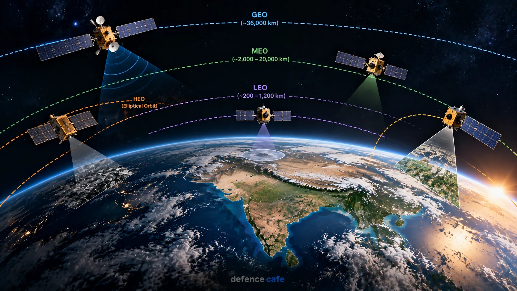
A satellite is a spacecraft designed to operate in space for a specific mission. But there is no single “standard” satellite. One may relay television and internet signals, another may photograph crops and coastlines, another may provide navigation signals, while another studies the Sun, planets or the changing Earth.
The most useful way to understand satellites is through three separate questions: what the satellite is designed to do, what kind of orbit it uses, and what equipment — or payload — it carries. These categories overlap. A satellite can be an Earth-observation satellite and also operate in a sun-synchronous polar orbit, for example.
India’s space programme uses satellites across communications, Earth observation, navigation, meteorology and scientific research. ISRO’s own satellite overview groups its spacecraft activities around communication, Earth observation, scientific, navigation, experimental, small and student satellite programmes. ISRO’s satellite overview provides the official classification and examples.
What Is a Satellite?
A satellite is an object placed into orbit around a larger body. In this article, the term primarily refers to artificial satellites — human-made spacecraft operating around Earth, the Moon or other destinations.
A satellite does not simply “float” in space. It is continuously falling toward the body it orbits while moving sideways at high speed. The combination of its velocity and gravity produces an orbital path.
The satellite’s mission depends on everything surrounding that basic orbital motion. It needs power, communications, thermal control, attitude control and a way to perform its assigned task.
Satellite vs Payload
This distinction is important.
The spacecraft bus provides the infrastructure needed to keep the satellite alive and operational. Depending on the mission, that can include power systems, computers, communications equipment, thermal control, attitude determination and control, propulsion and structural systems.
The payload is the mission-specific equipment. On one spacecraft that might be a television and communications transponder. On another it could be a high-resolution camera, synthetic-aperture radar, navigation payload, astronomical telescope or scientific instrument.
ESA describes payload systems as covering instruments such as Earth-observation sensors, scientific instruments, communications payloads and navigation-related systems. A typical space mission also relies on a ground segment for tracking, commanding, receiving and processing data. ESA’s payload systems overview and ground-segment explanation describe these functions.
How Satellites Are Classified
There is no single classification system. Satellites can be grouped according to their mission, orbit, mass, or technology.
| Classification | Examples | What it tells you |
|---|---|---|
| By mission | Communication, Earth observation, navigation, science | What the satellite is designed to accomplish. |
| By orbit | LEO, MEO, GEO, polar, sun-synchronous | Where and how the satellite travels around Earth or another body. |
| By size | Small satellites, microsatellites, larger spacecraft | The physical and mass class of the spacecraft. |
| By technology or purpose | Experimental, technology demonstrator, student satellite | Whether the mission is primarily operational, experimental or developmental. |
These classifications are not mutually exclusive. For example, a small Earth-observation satellite can also be a technology demonstrator and can operate in a low Earth orbit.
1. Communication Satellites
Communication satellites act as relay stations in space. Instead of requiring a direct terrestrial connection between two distant points, signals can be sent from a ground station to a satellite and then transmitted onward.
This is especially useful when very large geographic areas have to be covered.
ISRO says communication satellites support applications including telecommunications, television broadcasting, satellite news gathering, weather forecasting, disaster warning and search-and-rescue services. India’s INSAT/GSAT family forms an important part of this infrastructure. ISRO’s communication satellite programme provides the official overview.
How a Communication Satellite Works
A ground station sends an uplink to the satellite. The satellite receives that signal through its payload, processes or frequency-translates it, amplifies it and sends it back toward Earth as a downlink.
The result is effectively a communication bridge thousands of kilometres above the planet.
Many traditional communications satellites are placed in or around geostationary orbit because a satellite in the right orbit can appear almost fixed over one region of Earth.
2. Earth Observation Satellites
Earth observation satellites are designed to collect information about the Earth’s land, oceans, atmosphere and environment.
The simplest version uses a camera. Modern systems can be much more sophisticated, using multispectral, hyperspectral, microwave or radar sensors.
ISRO says data from its Earth-observation satellites are used in agriculture, water resources, urban planning, rural development, mineral prospecting, forestry, ocean resources and disaster management. ISRO’s Earth-observation satellite catalogue documents the missions and their applications.
Optical Imaging
Optical instruments observe reflected sunlight or emitted infrared energy. They can produce imagery useful for mapping, agriculture, land-use monitoring and environmental studies.
Radar Imaging
Radar satellites are particularly valuable because radar can work differently from conventional optical cameras.
For example, ISRO’s RISAT-1 used a C-band Synthetic Aperture Radar payload that enabled imaging during both day and night and under cloudy conditions. Its applications included agricultural monitoring and disaster management. ISRO’s RISAT-1 mission page describes the system.
That capability matters during events such as cyclones or floods, when cloud cover can make conventional optical imagery difficult to use.
3. Navigation Satellites
Navigation satellites continuously transmit precisely timed signals. A receiver compares the arrival times of signals from multiple satellites and uses those measurements to calculate position and time.
India’s regional satellite-navigation system is NavIC, or Navigation with Indian Constellation.
ISRO describes NavIC as an independent regional navigation system providing positioning, navigation and timing services over India and the surrounding primary service area. Its architecture uses a combination of geostationary and inclined geosynchronous satellites together with an extensive ground segment. ISRO’s NavIC overview explains the space and ground segments.
Why Atomic Clocks Matter
Navigation depends heavily on accurate timing.
A receiver is effectively measuring how long a signal took to travel from a satellite to the user’s location. Even a very small timing error can translate into a meaningful position error.
That is why navigation spacecraft carry extremely precise timing systems. India’s second-generation NVS series also incorporates additional navigation capabilities, including L1-band signals. ISRO’s NVS-01 information notes that an indigenous atomic clock was flown on the spacecraft for the first time in that series. ISRO’s NVS programme information explains the system.
4. Meteorological Satellites
Weather satellites monitor the atmosphere, clouds, oceans and other environmental parameters needed for forecasting and disaster management.
They can observe cloud systems, atmospheric conditions and changing weather patterns over large areas, making them especially useful for cyclone monitoring and warnings.
India’s INSAT meteorological missions have also carried data-relay and search-and-rescue capabilities. ISRO’s description of INSAT-3D, for example, identifies enhanced meteorological observation, atmospheric sounding, weather forecasting and disaster warning as major purposes. ISRO’s INSAT-3D mission information provides the details.
5. Scientific Satellites
Scientific spacecraft are built primarily to answer questions about the universe, planets, the Sun, the atmosphere or the Earth itself.
India’s scientific missions include AstroSat, Aditya-L1, Chandrayaan spacecraft and XPoSat.
Aditya-L1 is particularly interesting because it does not orbit Earth like a conventional Earth-observation satellite. It operates in a halo orbit around the Sun-Earth L1 Lagrange point, allowing continuous observation of the Sun from a special gravitational geometry. ISRO says the spacecraft completed its first halo orbit in 2024 and has continued its scientific programme; in 2026, ISRO opened a further observation cycle to the scientific community. ISRO’s Aditya-L1 mission update and 2026 observation announcement provide the mission context.
6. Experimental and Technology-Demonstration Satellites
Not every spacecraft exists to provide an operational service.
Some are built specifically to prove a new technology before it is incorporated into a larger operational system.
India’s SpaDeX mission is a useful example. It used two small spacecraft to demonstrate rendezvous, docking and undocking technology in low Earth orbit. ISRO successfully docked the two spacecraft in January 2025 and subsequently demonstrated undocking in March 2025. ISRO’s SpaDeX mission information documents the docking demonstration.
The importance of such missions extends beyond the two spacecraft themselves. Autonomous rendezvous and docking are enabling technologies for future missions that may require multiple spacecraft to work together or transfer hardware between vehicles.
Satellite Orbits Explained
The orbit is one of the most important design choices in any satellite mission.
An orbit determines how high the spacecraft flies, how quickly it moves, how frequently it passes over a region and how much of Earth it can see at once.
Changing the orbit can therefore change the entire mission.
| Orbit | Approximate altitude / characteristic | Typical uses |
|---|---|---|
| LEO | Low Earth orbit; roughly below 2,000 km | Earth observation, science, technology demonstrations and many communications constellations. |
| MEO | Between LEO and geosynchronous altitude | Commonly used for navigation and selected communications missions. |
| GSO | Approximately 35,786 km for a one-day orbital period | Communications and other missions requiring broad regional coverage. |
| GEO | Special geosynchronous orbit: circular and over the equator | Communications, weather and persistent regional coverage. |
| Polar orbit | Passes approximately from pole to pole | Earth observation and global coverage over repeated passes. |
| Sun-synchronous orbit | A specialised type of polar orbit | Earth imaging under relatively consistent local lighting conditions. |
NASA’s published orbital terminology places LEO between about 80 and 2,000 km, MEO between about 2,000 and 35,786 km, and the geosynchronous region around 35,786 km. NASA’s Low Earth Orbit terminology reference provides those altitude ranges.
LEO: Low Earth Orbit
LEO is the region closest to Earth commonly used for satellites.
Its relatively low altitude makes it attractive for Earth imaging because the spacecraft can observe the planet at comparatively close range. The trade-off is coverage. A low-orbit satellite moves quickly across the sky and sees a smaller area at any one moment than a satellite much farther away.
ISRO operates numerous Earth-observation missions in low and sun-synchronous orbits. For example, EOS-01 was placed in LEO for Earth observation and disaster-management applications. ISRO’s EOS-01 mission page provides the mission details.
MEO: Medium Earth Orbit
MEO occupies the region between LEO and the geosynchronous altitude.
It is particularly important in global navigation architectures because a higher orbit allows a satellite to cover a much larger portion of Earth than a typical LEO spacecraft.
India’s NavIC system uses a different architecture based primarily on geostationary and inclined geosynchronous orbits rather than the medium-Earth-orbit architecture used by systems such as GPS.
GEO and GSO: What’s the Difference?
These terms are often used interchangeably, but they are not exactly the same.
Geosynchronous orbit refers to an orbit whose period matches Earth’s rotation. A spacecraft can therefore return to the same general position relative to Earth after one sidereal day.
Geostationary orbit is a special case: the orbit is circular, lies over the equator and moves in the same direction as Earth’s rotation. From the ground, such a satellite appears almost stationary above a fixed longitude.
This makes GEO particularly valuable for communications and continuous regional weather observation.
Polar and Sun-Synchronous Orbits
A polar orbit takes a spacecraft roughly over the Earth’s polar regions while the planet rotates beneath it.
Over multiple passes, this allows a satellite to observe large portions of the Earth’s surface.
A sun-synchronous orbit is a specialised type of polar orbit designed so that the spacecraft crosses a given region at approximately the same local solar time. This gives more consistent lighting conditions from one observation to another, which is extremely useful when comparing images over time.
ESA’s orbit guide explains polar and sun-synchronous orbits and why consistent lighting is valuable for Earth observation.
Many of India’s remote-sensing spacecraft use sun-synchronous polar orbits. ISRO’s Earth-observation catalogue lists numerous Cartosat, Resourcesat and other missions in SSPO configurations. ISRO’s Earth-observation mission catalogue provides individual examples.
What Is a Transfer Orbit?
Satellites do not always travel directly from the launch vehicle to their final operating orbit.
A launch vehicle may first place a spacecraft into a temporary or transfer orbit. The satellite then uses its own propulsion to raise or modify the orbit.
A classic example is a Geosynchronous Transfer Orbit (GTO), which is used as an intermediate path for reaching geosynchronous or geostationary orbit.
This distinction is important because reaching a transfer orbit is not necessarily the same as reaching the satellite’s final mission orbit.
NVS-02: Why Orbit Raising Matters
India’s NVS-02 mission provides a useful real-world illustration.
ISRO reported that NVS-02 separated successfully into an elliptical transfer orbit after its January 2025 launch, but the subsequent orbit-raising operation could not be completed. In its February 2026 technical update, ISRO attributed the problem to the drive signal not reaching the pyro valve of the oxidiser line in the orbit-raising engine system and said corrective actions had been incorporated into subsequent spacecraft work.
The mission demonstrates why satellite success is measured across the complete mission chain: launch, separation, orbit insertion, spacecraft commissioning and sustained operations. ISRO’s February 2026 NVS-02 technical update provides the official account.
How a Satellite Actually Does Its Job
A satellite’s mission can be understood as a chain of five steps:
- Sense or receive: a camera, radar, telescope, antenna or navigation payload gathers information or receives a signal.
- Process: onboard electronics condition, package or manage the information.
- Store: mission data may be temporarily stored onboard before a communication opportunity.
- Transmit: the satellite sends data to a ground station.
- Use: ground systems process the raw information into maps, weather products, scientific measurements, communications services or navigation information.
That final step is easy to overlook. A satellite does not automatically produce a useful map, crop forecast or scientific conclusion. Data have to be received, processed, calibrated and delivered to the people or systems that use them.
The Ground Segment: The Half of the System You Don’t See
From Earth, the satellite is the visible part of the mission. Operationally, however, a satellite depends heavily on the ground.
Ground stations track the spacecraft, send commands, receive telemetry and downlink mission data. Separate systems may process, archive and distribute that information.
ESA describes a typical Earth-observation ground segment as including a flight-control centre, antennas or ground stations, data processing, storage and distribution facilities. ESA’s ground-segment overview explains the relationship between the spacecraft and these terrestrial systems.
In practical terms, a satellite is therefore not just a machine in orbit. It is part of a larger space-and-ground system.
What Satellites Do for India
Satellites have become embedded in many activities that do not look like “space technology” from the ground.
Agriculture
Remote-sensing data can help estimate crop area, monitor crop conditions, study soils and support agricultural planning. ISRO says satellite remote sensing is used in several agricultural applications, including crop estimation and production-related analysis. ISRO’s agriculture and soil applications page describes these uses.
Disaster Management
Satellite imagery can help authorities monitor cyclones, floods, droughts, landslides, forest fires and other hazards.
ISRO’s disaster-management services include satellite-based products for planning, rescue and relief operations. ISRO’s space-based Earth-observation services describes how the data are applied.
Communications
Satellite links can connect distant regions and support telecommunications, broadcasting and other services where terrestrial infrastructure alone may not provide the required coverage.
Navigation
NavIC provides positioning, navigation and timing services for civilian and authorised applications across its service region.
Weather Forecasting
Meteorological spacecraft continuously monitor atmospheric and surface conditions over large regions, contributing to forecasting and disaster warnings.
Science
Scientific spacecraft allow researchers to study the Sun, stars, planets, the Earth’s atmosphere and other physical processes that cannot be observed adequately from the ground.
Satellites and Defence
Satellites are also part of India’s broader defence and national-security ecosystem.
Their uses can include secure or specialised communications, navigation and timing, Earth observation, meteorology and maritime or geographic awareness. The exact capabilities and operational details of military systems are not always publicly disclosed, so it is important to distinguish between confirmed public information and assumptions.
Two publicly documented examples illustrate the principle. GSAT-7 was designed as a communication satellite with coverage including India’s landmass and a wide oceanic region, while GSAT-7A was designed to provide Ku-band communication capability over the Indian region. ISRO’s GSAT-7 page and ISRO’s GSAT-7A page provide the public technical descriptions.
The larger point is that satellites extend the reach of systems on the ground, at sea and in the air. Communications, navigation and observation can all become more persistent when supported from orbit.
A Recent Example: NISAR
India’s satellite capability is no longer limited to separate national programmes. International cooperation is increasingly visible in advanced Earth-observation missions.
NISAR — the NASA-ISRO Synthetic Aperture Radar mission — combines NASA’s L-band radar with ISRO’s S-band radar on a single spacecraft. ISRO describes it as a dual-frequency microwave imaging mission designed to observe land, ice and selected ocean regions globally.
ISRO’s 2025 Department of Space achievements page states that NISAR had become fully operational, while the mission page records its entry into the science phase in November 2025. ISRO’s NISAR mission page provides the mission information.
NISAR is a useful example of how modern satellites can combine different sensor technologies rather than relying on a conventional optical camera alone.
Why One Satellite Cannot Do Everything
A common misconception is that a sufficiently advanced satellite could simply perform every job.
In practice, missions impose competing design requirements.
A satellite designed for high-resolution Earth imaging may benefit from a low orbit. A communications spacecraft serving a broad geographic region may benefit from a much higher orbit. A navigation system needs carefully controlled satellite timing and geometry. A scientific spacecraft may require an entirely different trajectory to observe the Sun or another celestial body.
Even within one category, different sensors can produce very different information.
That is why satellite systems are generally built around a specific mission requirement rather than trying to maximise every capability at once.
From Rockets to Satellites: Where the Launch Vehicle Fits
The rocket and the satellite have different jobs.
The launch vehicle provides the energy needed to carry the spacecraft from Earth to the required trajectory. Once separated, the satellite must perform its own mission and, when necessary, use onboard propulsion and control systems to reach or maintain its operational orbit.
ISRO currently identifies the PSLV, GSLV and LVM3 as its three active operational launch vehicles. ISRO describes PSLV as a versatile launcher used for Earth-observation, geostationary and navigation payloads, while GSLV and LVM3 provide capabilities for heavier spacecraft and different orbital requirements. ISRO’s launch vehicle overview provides the official distinction.
This is why a satellite programme is more than spacecraft manufacturing. It also requires launch capability, mission control, ground stations, orbital operations and data infrastructure.
How to Read a Satellite Mission at a Glance
When you see a satellite launch announcement, five questions can quickly reveal what the mission is about:
- What is the payload? Camera, radar, communications transponder, navigation payload, telescope or another instrument?
- What is the target orbit? LEO, MEO, GEO, polar, sun-synchronous or a specialised trajectory?
- What is the mission? Communication, Earth observation, navigation, weather, science or technology demonstration?
- What happens after separation? Does the spacecraft need orbit raising, deployment, commissioning or other manoeuvres?
- Who uses the data? Scientists, governments, commercial users, defence organisations, emergency agencies or the public?
These questions often tell you more about a spacecraft’s real purpose than its size or launch vehicle alone.
What to Watch in India’s Satellite Programme
India’s satellite ecosystem is moving toward increasingly capable sensors, higher-value data products, specialised navigation systems, spacecraft autonomy and missions that require multiple spacecraft to cooperate.
Recent developments illustrate several of these directions:
- NISAR: advanced dual-frequency radar Earth observation through an ISRO-NASA partnership.
- NavIC’s NVS series: continued evolution of India’s regional positioning, navigation and timing infrastructure.
- SpaDeX: demonstrated rendezvous, docking and undocking of two spacecraft.
- Aditya-L1: continued solar observations from the Sun-Earth L1 region.
These programmes point toward a space ecosystem in which satellites are increasingly expected not just to collect data, but to operate as part of larger networks of spacecraft, launch systems and ground infrastructure.
Frequently Asked Questions
What are the main types of satellites?
The main mission categories include communication, Earth observation, navigation, meteorological and scientific satellites. There are also experimental, small and student satellite programmes.
What is the difference between LEO and GEO?
LEO is much closer to Earth and is commonly used for Earth observation and many low-orbit missions. GEO is a special geosynchronous orbit about 35,786 km above the equator where a satellite can appear nearly stationary over one longitude.
What is a geostationary satellite used for?
Geostationary satellites are particularly useful for communication and continuous regional observation because they remain apparently fixed above a particular part of Earth.
Why do Earth-observation satellites often use sun-synchronous orbits?
A sun-synchronous orbit allows a spacecraft to pass over a given region at approximately the same local solar time, making lighting conditions more consistent when comparing images taken on different dates.
Is NavIC the same as GPS?
No. GPS is the United States’ global satellite-navigation system. NavIC is India’s independent regional navigation system, designed primarily for India and its surrounding service area.
What does an Earth-observation satellite do?
It collects information about the Earth’s surface or atmosphere using instruments such as optical cameras, multispectral sensors or radar. The resulting data can support agriculture, mapping, disaster management, water resources, environmental monitoring and other applications.
Can satellites take pictures at night?
Some can. Conventional optical imaging depends heavily on available light, while radar instruments can operate independently of sunlight. ISRO’s RISAT-1, for example, used Synthetic Aperture Radar capable of day-and-night imaging.
What is a satellite payload?
The payload is the mission-specific equipment carried by a spacecraft, such as a camera, radar, communications transponder, navigation instrument or scientific sensor.
What is the difference between a satellite and a launch vehicle?
A launch vehicle carries the spacecraft into space and places it on the required trajectory. The satellite then operates as the mission spacecraft, using its own systems to perform its assigned task.
Conclusion
Satellites are not a single technology. They are a collection of specialised spacecraft designed around very different missions.
Communication satellites connect users across large distances. Earth-observation satellites watch the land, oceans and atmosphere. Navigation satellites provide precise positioning and timing. Weather spacecraft support forecasting and warnings. Scientific satellites study the Sun, Earth and the wider universe.
The orbit is just as important as the payload. LEO, MEO, GEO, polar and sun-synchronous orbits each create different trade-offs in coverage, observation geometry, communications and mission operations.
For India, the satellite programme has evolved into a broad ecosystem involving communications, remote sensing, navigation, science, meteorology, technology demonstrations and increasingly sophisticated orbital operations.
The most important idea to remember is simple: a satellite is not valuable merely because it is in space. Its value comes from the information or service it can deliver back to Earth.
Sources & Further Reading
- ISRO — Satellites: Communication, Earth Observation, Scientific, Navigation and Other Satellite Programmes
- ISRO — Launch Vehicles: PSLV, GSLV and LVM3
- ISRO — Earth Observation Satellites and Applications
- ISRO — Communication Satellites / INSAT-GSAT System
- ISRO — Satellite Navigation Services and NavIC
- ISRO — NVS-02 Spacecraft: On-Orbit Observations and Technical Findings
- ISRO — NISAR: NASA-ISRO Synthetic Aperture Radar Mission
- ISRO — SpaDeX: Successful Docking of Two Spacecraft
- ISRO — Aditya-L1 Mission: Completion of First Halo Orbit
- NASA — Economic Development of Low Earth Orbit: Orbital Terminology and Altitudes
- European Space Agency — Types of Orbits
- European Space Agency — Payload Systems
- European Space Agency — Ground Segment Overview
